SP2: Interaction between climate and land surfaces: Regional Assessment
-
Scope
Subproject SP 2 focuses on the modeling of atmosphere-land surface interactions using a regional Earth System Model like WRF-Hydro. We will assess the coupled atmospheric and terrestrial regional water cycle in high spatial resolution for the entire region of southern Africa and derive indicators and measures for land surface-atmosphere interactions.
-
The objectives
- Adapting, improving, and applying the regional earth system model (ESM) WRF-Hydro
to describe the regional terrestrial water balance in southern Africa in a very high
resolution (4 km). In particular, the coupled atmospheric-terrestrial water balance as
well as the interactions between atmosphere and land surface in the region are
analyzed and quantified with WRF-Hydro. - Analyzing the impact of an extremely high resolution (1 km) in WRF-Hydro for selected sub regions and study periods, under different assumptions of land use- and climate change scenarios.
- Providing improved input data for impact studies of erosion- and degradation scenarios.
- Adapting, improving, and applying the regional earth system model (ESM) WRF-Hydro
-
The methodology
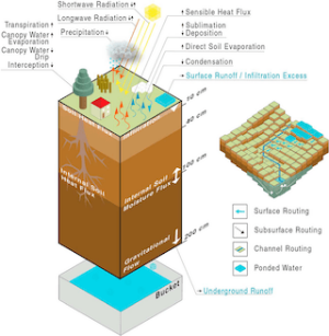
The main focus has been set on estimating the soil- and heat fluxes for the lower atmospheric boundary conditions, such as for the regional model WRF, which is coupled to the Noah Land Surface Model for this reason. In the past few years, fully coupled atmospheric-hydrological models have been developed in order to model the spatial variability of the soil moisture in a more realistic way (e.g. MAXWELL et al., 2007; et al., 2016).
In WRF-Hydro, for instance, the lateral redistribution of the infiltration excess along the topography is treated using a 2-dimensional description. Numerous studies have shown that the description of the terrestrial water flow has a significant effect on surface fluxes and the dynamics of the planetary boundary layer (PBL), and thus influences hydrometeorological parameters such as precipitation.
For this reason, the fully-coupled model WRF-Hydro will be used for the first time for the South Africa region and for the first time in a climate mode within SALDi. In studies dealing with the impact of land use changes on the regional climate uncertainties are often neglected. In analogy to climate change uncertainties (e.g. HAUGHTON et al., 2014), RCM ensemble simulations with disturbed boundary conditions are also needed in land use studies to identify robust signals (LAUX et al., 2016). A further source of uncertainty in the performance of RCMs is the use of the horizontal grid resolution, the topography, and the convection parameterization (WAGNER et al., 2017).
Therefore, SALDi is particularly concerned with the question to which extent the description of hydrometeorological variables can be improved when using a convection-permitting model horizontal resolution (~4 km), and whether the massive increase in computation time can be justified. Such estimates are being performed in SALDi for singled years and selected simulation periods.
-
The cooperation
Subproject SP 2 is led by the Institute of Geography of University Augsburg (UNIA-IG).
During the project period, SP2 will initiate a cooperation with the climate modelling group of the CSIR in order to exchange experience about regional climate modelling for the SA region. CSIR has proven expertise in atmospheric modelling at time scales ranging from short-range weather forecasting through to projections of future climate change, and at spatial scales that vary from relatively low-resolution global simulations, to ultra-high resolution simulations at the micro-scale using the RCM CCLM (ENGELBRECHT et al., 2011). This might also facilitate RCM comparison studies.
-
The expected results
Milestone 1: SALDi Kickoff Meeting with 1st SALDi Summer School completed
Milestone 2: WRF Hydro Simulations for South Africa finished
Milestone 3: High resolution simulations for selected EZGs finished
Milestone 4: WRF Hydro simulations sing selected land use scenarios completed
Milestone 5: Key parameters of the interactions between climate and land surface derived for different degradation scenarios
Milestone 6: 2nd SALDi Summer School and final joint SALDi balance meeting carried out,
joint publication(s) with South African partners completed
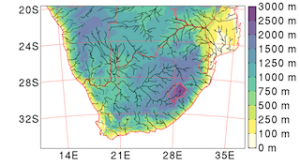
WRF-HYDRO setup SA region
Image: https://agupubs.onlinelibrary.wiley.com/doi/pdf/10.1029/2018JD029004Setup WRF-HYDRO for entire South African region. The figure depicts the topography and rivers of the WRF-Hydro setup:
- WRF domain to resolve atmospheric and land surface processes: 500x350 horizontal grid points with a 5km grid spacing, 50 vertical levels up to 10hPa,
- model integration time step of 30s,
- Hydro subdomain to resolve the lateral terrestrial water flow: 5000x3500 horizontal grid points with a 500m grid spacing,
- This setup will be used to investigate land-atmosphere interaction processes in the Southern African regions.
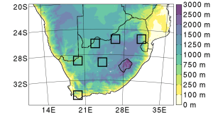
WRF-HYDRO model setup
Image: https://agupubs.onlinelibrary.wiley.com/doi/pdf/10.1029/2018JD029004WRF-Hydro model setup:
- 6 Inner domains encompassing the study regions. Each subdomain consists of 150x150 grid points at a grid spacing of 1km.
- This setup will be used to deliver high resolution precipitation datasets (5min, 1km) for the study regions under the assumption of different land-use and climate change scenarios.
- This setup will be used to derive degradation scenarios and hazards of potential erosion.
Alter Postweg 118
86159 Augsburg
Google Maps site planExternal link


